
Bucholz Aaf(Kwajalein Kmr)(Atoll) Airport
KWA · PKWA · Kwajalein, · Marshall Islands County · map
Bucholz Aaf(Kwajalein Kmr)(Atoll) Airport is a private airport owned by the US Army Aeronautical Svcs Agency in Kwajalein, , 16 feet above sea level. Its one runway, 06/24, is 6,668 feet of asphalt. It has a control tower.
Private use: permission from the owner is required before landing here.
The airport
- Codes
- FAA KWA · ICAO PKWA
- Kind
- Airport · private use, permission required · owned by the Army
- Owner
- US Army Aeronautical Svcs Agency
- Elevation
- 16 feet above sea level
- Control tower
- A control tower · 2000-0400z tue-sat, excld fed holidays
- Attended
- every day, 7:30 am to 9:30 pm
- Lights
- beacon sunset to sunrise
- Fuel and services
- no fuel reported; the services card below
- On the chart
- Gnc 7 sectional
- Magnetic variation
- 9E
Runway
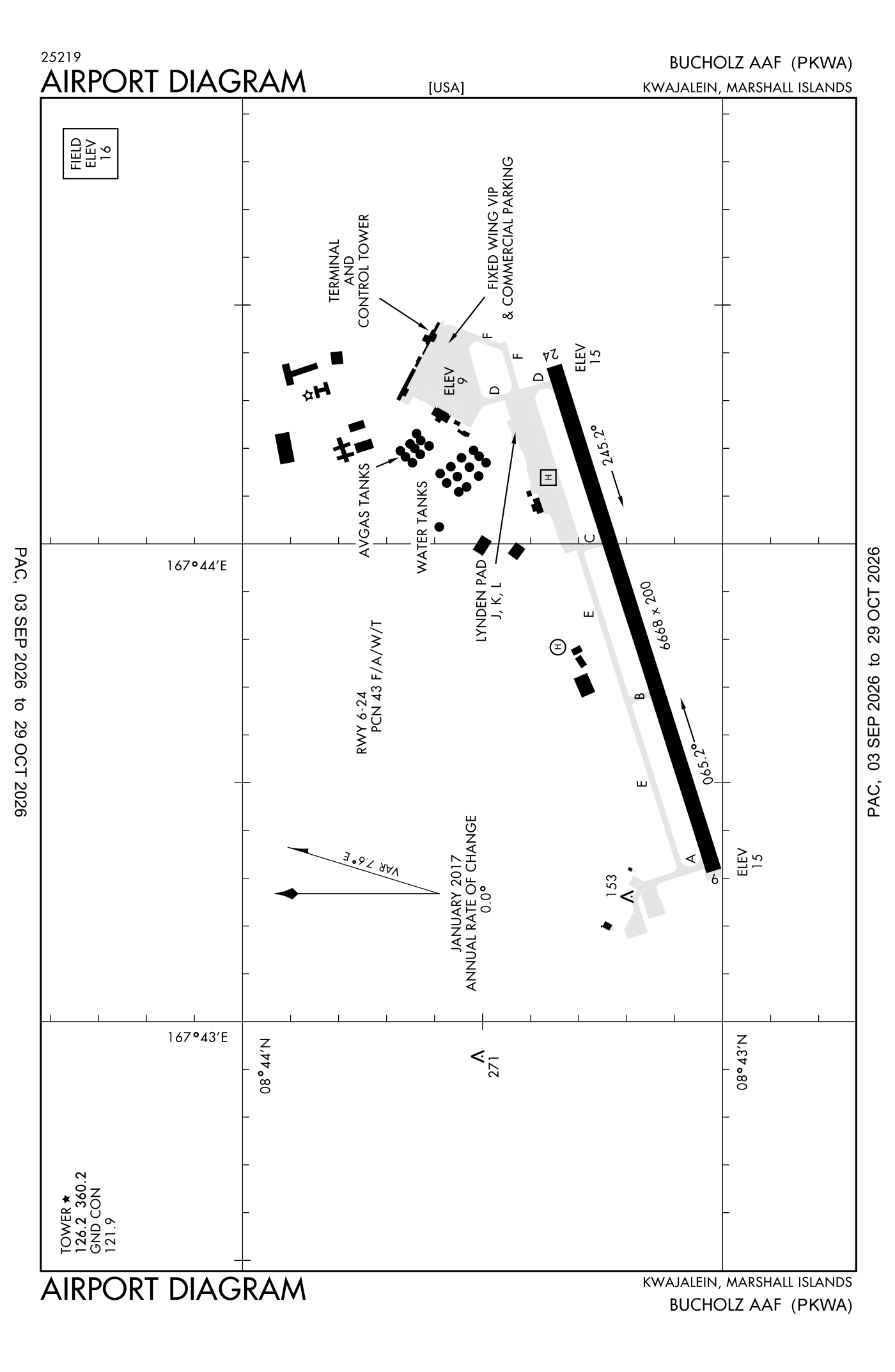
For understanding the field, not for navigation.
| Runway | Length × width | Surface | Lights |
|---|---|---|---|
| 06/24 | 6,668 × 200 ft | Asphalt | High-intensity lights |
- Runway 06: PAPI, four lights on the left
- Runway 24: PAPI, four lights on the left
Radio frequencies
| Ground | 121.9 | Kwajalein |
| Tower | 126.2 | Kwajalein |
| Emergency | 121.5 | Kwajalein |
| Base Operations Advisory Svc | 118.8 | Kwajalein |
Aircraft registered in Kwajalein from the FAA register
No aircraft on the register list Kwajalein, as the owner's town.
Fuel and services as reported to the FAA
- Fuel
- none reported
- Oxygen
- bulk oxygen (high- and low-pressure)
The FAA's file records what is sold and done at the field, as the airport manager reports it, not who sells it or the price; fuel sellers (FBOs) are not named in any public file.
Accidents and incidents at or near this airport NTSB records · 1 since 1982, 0 fatal
Cases the NTSB recorded with this as the nearest airport, newest first. Each opens the full report in plain English. The country as a whole: Where accidents happen.
The FAA's remarks as written in the airport file, spelled out
- 250 feet tower 8.5NM pkwa brg 300DEG.
- CTN-PILOTS have experienced vertigo dur night operns especially dur periods of reduced visibility due to lack of visual cues.
- Afct with explosive cargo should plan to arrive between 8:30 am to 5:30 pm local.
- Caution: men, equip, and vehicles may be operates in close proximity to the runway. 250 feet tower 8.5 NM wnw. Vertigo potential exists dur night operates especially dur periods of reduced visibility due lack of visibility cues. Avoid rain catchments on north side of runway and taxiway. Portions of taxiway east not visibility FR tower. No ovrn available. Numerous trees and other obstruction within 300 feet south of runway. Seawall at EA end of runway. ELECTRO-MAGNETIC radiation may exist 24 hour daily within 5 NM surface to 30,000 feet. Contact base operations or tower prior to arrival and departure for ELECTRO-MAGNETIC radiation haz DE-CONFLICTION.
- Transit alert contractor assistance available 7:30 am to 7:30 pm local.
- Arrival/departure should not be planned between 1:00 pm to 7:30 am local.
- Avoid rain catchments on north side of runway and taxiway.
- (A70) fuel code JP-5
- Tacan tower 75 feet high located 164 feet north of taxiway east centerline.
- Portions of taxiway east not visibility from the control tower.
- Numerous trees and other obstruction within 300 feet south of runway.
- Use of parallel taxiway a lmtd to C-141 and smaller aircraft.
Connections how this airport links to the rest of the register
- NTSB accidents and incidents at or near this airport 1 since 1982 · 0 fatal
The whole map of how records connect · these connections as data: /graph/airport/KWA.json.
Facts from the FAA's airport file effective October 1, 2026, written out in plain English; weather from the National Weather Service's aviation weather service; registered aircraft from the FAA register as of October 9, 2026; accidents from the NTSB's public database. Owners are shown only when they are an organisation; no person is named. Check the official sources before a flight: this page is for understanding an airport, not for planning one.