
Wake Island Airfield
AWK · PWAK · Wake Island, QW · Wake Island County · map
Wake Island Airfield is a private airport owned by the Air Force in Wake Island, QW, 23 feet above sea level. Its one runway, 10/28, is 9,844 feet of asphalt.
Private use: permission from the owner is required before landing here.
Weather right now PWAK · observed 11:55 am +12 (23:55 UTC), 60 minutes ago
VFR good flying weather
- Wind from the east-northeast (060°) at 17 knots
- Visibility 7 miles
- Sky: a few clouds at 2,000 feet
- Temperature 89°F (32°C), dew point 77°F (25°C)
- Altimeter 29.95 inHg
The forecast issued Mon 10:00 am +12 (22:00 UTC), good until Tue 4:00 pm +12 (04:00 UTC)
- From Mon 10:00 am +12 (22:00 UTC): wind from the east-northeast at 15 knots, scattered clouds at 2,000 feet, scattered clouds at 2,500 feet and more above VFR
- At times between Mon 10:00 am +12 (22:00 UTC) and 4:00 pm +12 (04:00 UTC): wind from the east-northeast at 16 knots, gusting to 22, light rain showers, a broken layer at 1,800 feet MVFR
- At times between Tue 1:00 am +12 (13:00 UTC) and 7:00 am +12 (19:00 UTC): wind from the east-northeast at 18 knots, light rain showers, a broken layer at 2,100 feet MVFR
The codes as issued (METAR and TAF)
METAR PWAK 112355Z AUTO 06017KT 7SM FEW020 32/25 A2995 RMK AO2 SLP145 60000 T03170248 10317 20279 58008
TAF PWAK 112200Z 1122/1304 06015KT 9999 SCT020 SCT025 BKN045 QNH2983INS TEMPO 1122/1204 07016G22KT 8000 -SHRA BKN018 TEMPO 1213/1219 07018KT 8000 -SHRA BKN021 TX32/1220Z TN27/1203Z
From the National Weather Service's aviation weather service, refreshed every few minutes; times are local to the airport with UTC in brackets. For a flight, get your briefing from Flight Service or an approved provider.
The airport
- Codes
- FAA AWK · ICAO PWAK
- Kind
- Airport · private use, permission required · owned by the Air Force
- Owner
- Air Force
- Elevation
- 23 feet above sea level
- Control tower
- No control tower
- Attended
- every day, except holidays; Monday to Saturday, 7:00 pm to 0500z
- Lights
- beacon sunset to sunrise
- Fuel and services
- no fuel reported; the services card below
- On the chart
- Gnc 7 sectional
- Magnetic variation
- 6E
- In the FAA's files since
- December 1952
Runway
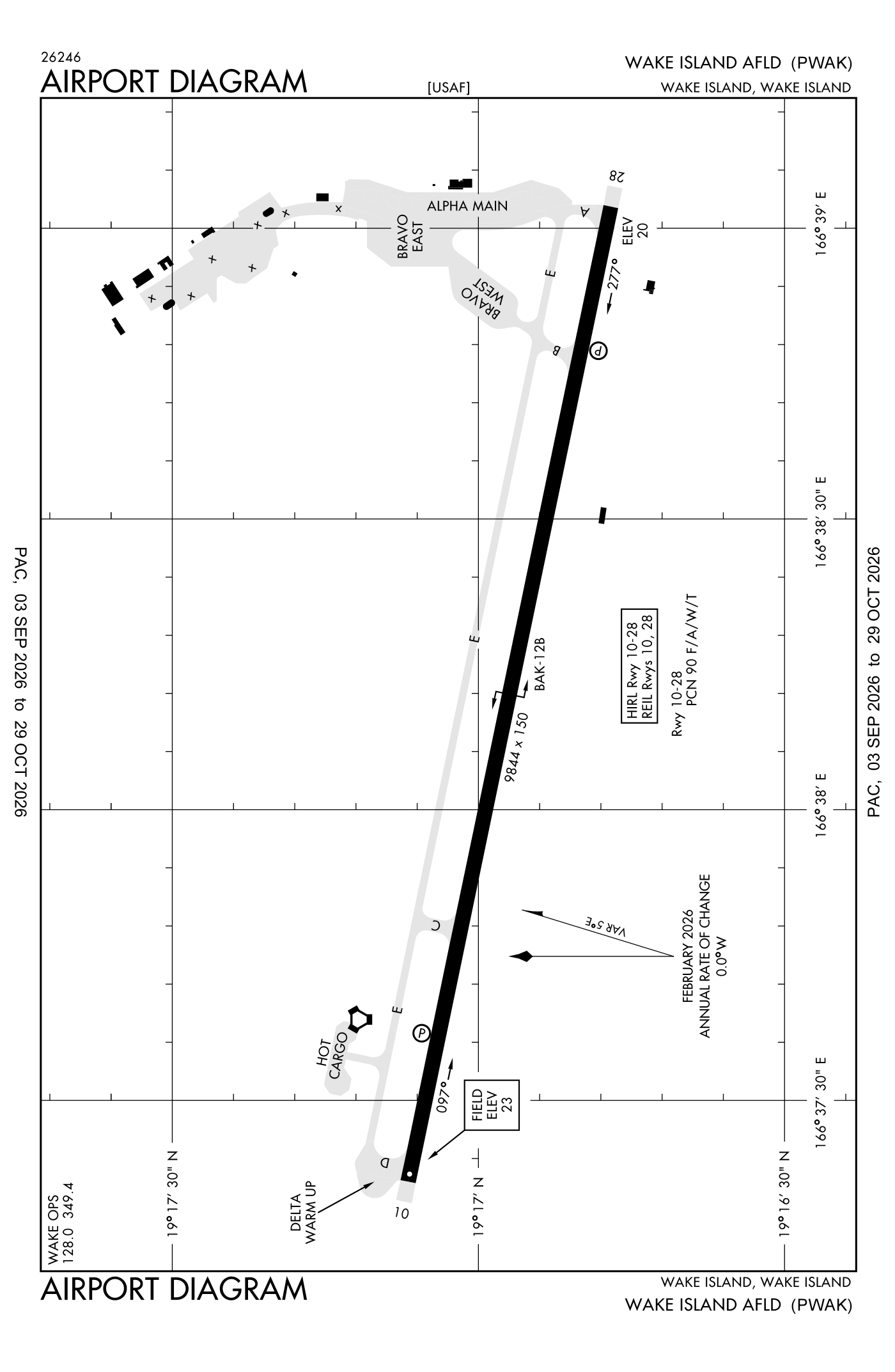
For understanding the field, not for navigation.
| Runway | Length × width | Surface | Lights |
|---|---|---|---|
| 10/28 | 9,844 × 150 ft | Asphalt | High-intensity lights |
- Runway 10: PAPI, four lights on the left
- Runway 28: PAPI, four lights on the left
Aircraft registered in Wake Island from the FAA register
No aircraft on the register list Wake Island, QW as the owner's town.
Fuel and services as reported to the FAA
- Fuel
- none reported
- Repairs
- none at the field, as reported
The FAA's file records what is sold and done at the field, as the airport manager reports it, not who sells it or the price; fuel sellers (FBOs) are not named in any public file. Airports selling jet fuel in QW · avgas.
Accidents and incidents at or near this airport NTSB records
No NTSB accident or incident records name this airport.
The FAA's remarks as written in the airport file, spelled out
- Airport will be considered a joint use airport open to civil aircraft subject to military reqrmnts.
- (0700-1700L TUE-SAT)
- 900' coral overrun.
- Fuel: flight crew required to assist in refueling. J5(military). Fluid - west, SP, presair.
- Caution - bird haz on approach runway 10 or runway 28 departure. If takeoff and landing data permits, recommend conducting all flight operations to/from the east side of the runway.
- Restricted: no aircraft maintenance available. Taxiway line restriction located at intersection of taxiway echo and delta. Continues (west) onto the WARM-UP pad does not provide wingtip clearance to aircraft with wingspan greater than 60 feet.
- Be alert to ocean vessels with mast approximately 125 feet periodically located at mooring buoys 3600 feet west of thld runway 10.
- Arresting gear - (runway 28) hook bak 12B (4921').
- Restricted: very limited operations status, available for emergency landing and minimum priority traffic.
- Traffic pattern: right break runway 10 all aircraft, left break runway 28 all aircraft.
- Tran alert: svcg fees rqd. Tran service hours 1900-0500Z (0700L-1700L) TUE-SAT. closed Sunday, Monday, holidays. Lav service unavailable.
- Misc: etops divert lctn. Firefighting services reduced to nfpa cat 7, rescue and firefighting (ARFF) index C.
Connections how this airport links to the rest of the register
- Accidents and incidents in QW 0 since 1982 · 0 in the last ten years
The whole map of how records connect · these connections as data: /graph/airport/AWK.json.
Facts from the FAA's airport file effective October 1, 2026, written out in plain English; weather from the National Weather Service's aviation weather service; registered aircraft from the FAA register as of October 9, 2026; accidents from the NTSB's public database. Owners are shown only when they are an organisation; no person is named. Check the official sources before a flight: this page is for understanding an airport, not for planning one.